
View this world map to locate all seven continents: Click on it to make it BIG!!
Play this game to review the location of the continents:
Continents Game
Read the information below and decide which continent you would be most interested in learning more about.
Fun Facts about the continents
Play this game to review the location of the continents:
Continents Game
Read the information below and decide which continent you would be most interested in learning more about.
Fun Facts about the continents
Asia
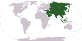
The continent of Asia is the world's largest and most populous continent with nearly 4 billion people calling Asia home. Asia also contains the world's most populous country, China, and the worlds largest country, Russia. Asia borders Africa and Europe to the west and the Pacific Ocean to the east.
The continent of Asia is so large and diverse that it often is divided into sub-regions (see map below).
Northern Asia
Middle East
Southern Asia
Eastern Asia
Southeastern Asia 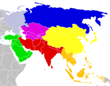
Asia is rich in diverse races, cultures, and languages. Many of the world's major religions came out of Asia including Christianity, Judaism, Islam, Hinduism, and Buddhism.
Asia has a major influence on world culture and the world's economy. Countries such as Russia, China, Japan and India produce products and services that are used by every nation in the world. Asia is also abundant in natural resources. Oil in the Middle East is a major supplier of much of the world's energy.

Countries of Asia
Learn more about the countries from the continent of Asia. Get all sorts of information on each Asian country including a map, a picture of the flag, population and much more. Select the country below for more information:
Afghanistan
Armenia
Azerbaijan
Bangladesh
Bhutan
China
Georgia
India Japan
Kazakhstan
Korea, North
Korea, South
Kyrgyzstan
Maldives
Mongolia
Nepal Pakistan
Russia
Sri Lanka
Tajikistan
Turkmenistan
Uzbekistan
Ukraine
Fun Facts about Asia:
Asia is almost 30% of the worlds land area and contains 60% of the worlds population.
The highest point on earth, Mt. Everest, is in Asia. The lowest point on land, the Dead Sea, is also in Asia.
The Great Wall of China is the only man made structure that can be seen from space.
Asia is the only continent that border two other continents; Africa and Europe. It sometimes joins with a third continent, North America, in the winter by ice forming in the Bering Sea.
Asia contains many of the largest cities in the world including the two largest; Shanghai, China and Mumbai, India.
Africa
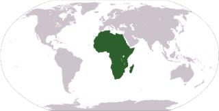
The continent of Africa borders the southern half of the Mediterranean Sea, the Atlantic Ocean is to the west, and the Indian Ocean is to the Southeast. Africa stretches well south of the equator to cover more than 12 million square miles making Africa the world's second largest continent. Africa is also the world's second most populous continent. Africa is one of the most diverse places on the planet with a wide variety of terrain, wildlife, and climates.
Countries of Africa
Learn more about the countries from the continent of Africa. Get all sorts of information on each African country including a map, a picture of the flag, population and much more. Select the country below for more information:
Fun Facts about Africa:
The highest point in Africa is Mount Kilimanjaro in Tanzania at 5895 meters high, the lowest point is Lake Asal in Djibouti at 153 meters below sea level.
The largest country in Africa is Sudan, the smallest is The Seychelles. The most populated country is Nigeria and the largest city is Cairo in Egypt.
The largest lake in Africa is Lake Victoria and the longest river is The Nile River, which is also the longest river in the world.
Africa is rich with varied wildlife including elephants, penguins, lions, cheetahs, seals, giraffes, gorillas, crocodiles, and hippos.
African languages are varied with more than 1000 languages spoken across the continent.
North America
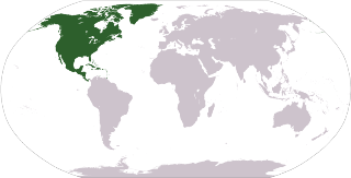
North America is the third largest of the seven continents. It is bordered by the Atlantic Ocean in the East and the Pacific Ocean in the west. North America is dominated by its three largest countries: Canada, Mexico, and the United States. Central America and the Caribbean are usually considered part of North America, but they have their own section here (see link).
Although Columbus is given much credit as having discovered America, there were plenty of people already living in North America prior to the Europeans having arrived including the Aztec civilization in what is now Mexico. In the 1600's the Europeans quickly colonized and took over much of North America. The largest country in North America, the United States, was formed in the late 1700's and became a "melting pot" of people and cultures from around the world.
Countries of North America
Learn more about the countries from the continent of North America. Get all sorts of information on each North American country including a map, a picture of the flag, population and much more. Select the country below for more information:
Bermuda
Canada Greenland
Mexico Saint Pierre and Miquelon
United States
Fun Facts about North America:
The city with the largest population in North America is Mexico City, Mexico. The most populous country is the United States. (2010 census)
The longest river in North America is the Mississippi River.
Lake Superior is the largest fresh water lake in the world. It is located on the border between the United States and Canada.
The country of Greenland is the biggest island on the planet.
The North American and South American continents are thought to have been named after Italian explorer Amerigo Vespucci.
South America
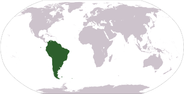
South America is the fourth largest continent in size and the fifth largest in population. It is located primarily in the southern hemisphere, is bordered by the Atlantic Ocean to the east and the Pacific Ocean to the West. The geography of South America is dominated by the Andes Mountain Range and the Amazon River (second longest river in the world).
Prior to European colonization, the Incan Civilization was a dominant force in South America. In the 1500's, Spain and Portugal colonized much of South America. The colonies gained independence in the 1800's with the help of leaders such as Simon Bolivar and Jose de San Martin. As a result, much of South America still speaks Spanish and Portuguese is the primary language of Brazil.
Countries of South America
Learn more about the countries from the continent of South America. Get all sorts of information on each South American country including a map, a picture of the flag, population and much more. Select the country below for more information:
Argentina
Bolivia
Brazil
Chile
Colombia Ecuador
Falkland Islands (Islas Malvinas)
French Guiana
Guyana
Paraguay Peru
Suriname
Uruguay
Venezuela
Fun Facts about South America:
The highest point in South America is Cerro Aconagua in the Andes Mountains in the country of Argentina.
The largest South American country in both size and population is Brazil. The largest city is Sao Paulo, Brazil, which is the fifth largest country in the world.
North and South America were named after Italian explorer Amerigo Vespucci.
The highest waterfall in the world is Santo del Angel. It is almost 1000 meters high!
Europe
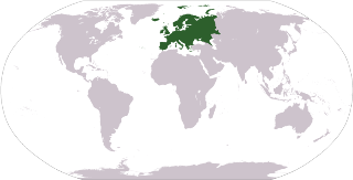
Europe is the sixth largest continent in size and the third largest in population. It is bordered by the Mediterranean Sea to the south, Asia to the east, and the Atlantic Ocean to the West. Europe is a wealthy continent and is the center of the West and Western Democracy.
Europe has been the home to some of the earth's greatest civilizations from Ancient Greece to the Roman Empire. It is also the home to the birth of democracy. Europe has also been the central point of two of the biggest wars in modern history: World War I and World War II. Recently Europe has united under the common union called the European Union. This union allows independent European countries to have a single currency and to combine their economic and military power.
Countries of Europe
Learn more about the countries from the continent of Europe. Get all sorts of information on each Europe country including a map, a picture of the flag, population and much more. Select the country below for more information:
Fun Facts about Europe:
Europe is the home to many of the world's oldest countries including the 5 oldest; San Marino, France, Bulgaria, Denmark, and Portugal.
Europe is home to the smallest country in the world, the Holy See or the Vatican. It is the smallest country both in size and population.
The tallest mountain in Europe is Mount Elbrus in Russia.
Most of Europe now uses the same currency called the Euro.
The area of Russia that is west of the Ural Mountains is usually considered part of Europe.
Antarctica
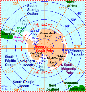
- Geography: Antarctica is the icy continent at the South Pole. It is covered by permafrost (permanently frozen ground), is surrounded by water, and is about 1 1/2 times larger than the United States. The world's largest desert is on Antarctica. 98 percent of the land is covered with a continental ice sheet; the remaining 2 percent of land is barren rock. Antarctica has about 87% of the world's ice.
- Climate: The South Pole is the coldest, windiest, and driest place on Earth. The coldest temperature ever recorded on Earth was at the South Pole; it reached -128.6°F (-88.0°C)! On average, most of Antarctica gets less than 2 inches of snow fall each year.
- People: Although scientific expeditions visit Antarctica, there are no permanent human residents (because of the extreme weather, which includes freezing temperatures, strong winds, and blizzards). There are about 4,000 seasonal visitors to Antarctica.
- Location: Antarctica hasn't always been located at the South Pole. It has drifted, like the other continents, and has ranged from the equator (during the Cambrian period, about 500 million years ago) to the South Pole. During the time of the dinosaurs (the Mesozoic Era, about 65 million to 248 million years ago), Antarctica was more temperate and housed dinosaurs and many other life forms. Now, there is very little indigenous life.
Austrailia
Travel here to learn more about Austrailia (just click next to see more information)
Click here>> Austrailia
Asia
Northern Asia
Middle East
Southern Asia
Eastern Asia
Southeastern Asia
Middle East
Southern Asia
Eastern Asia
Southeastern Asia
Countries of Asia
Learn more about the countries from the continent of Asia. Get all sorts of information on each Asian country including a map, a picture of the flag, population and much more. Select the country below for more information:
| Afghanistan Armenia Azerbaijan Bangladesh Bhutan China Georgia India | Japan Kazakhstan Korea, North Korea, South Kyrgyzstan Maldives Mongolia Nepal | Pakistan Russia Sri Lanka Tajikistan Turkmenistan Uzbekistan Ukraine |
Asia is almost 30% of the worlds land area and contains 60% of the worlds population.
The highest point on earth, Mt. Everest, is in Asia. The lowest point on land, the Dead Sea, is also in Asia.
The Great Wall of China is the only man made structure that can be seen from space.
Asia is the only continent that border two other continents; Africa and Europe. It sometimes joins with a third continent, North America, in the winter by ice forming in the Bering Sea.
Asia contains many of the largest cities in the world including the two largest; Shanghai, China and Mumbai, India.
Africa
The continent of Africa borders the southern half of the Mediterranean Sea, the Atlantic Ocean is to the west, and the Indian Ocean is to the Southeast. Africa stretches well south of the equator to cover more than 12 million square miles making Africa the world's second largest continent. Africa is also the world's second most populous continent. Africa is one of the most diverse places on the planet with a wide variety of terrain, wildlife, and climates.
Countries of Africa
Learn more about the countries from the continent of Africa. Get all sorts of information on each African country including a map, a picture of the flag, population and much more. Select the country below for more information:
Africa

Fun Facts about Africa:
The highest point in Africa is Mount Kilimanjaro in Tanzania at 5895 meters high, the lowest point is Lake Asal in Djibouti at 153 meters below sea level.
The largest country in Africa is Sudan, the smallest is The Seychelles. The most populated country is Nigeria and the largest city is Cairo in Egypt.
The largest lake in Africa is Lake Victoria and the longest river is The Nile River, which is also the longest river in the world.
Africa is rich with varied wildlife including elephants, penguins, lions, cheetahs, seals, giraffes, gorillas, crocodiles, and hippos.
African languages are varied with more than 1000 languages spoken across the continent.
North America
North America is the third largest of the seven continents. It is bordered by the Atlantic Ocean in the East and the Pacific Ocean in the west. North America is dominated by its three largest countries: Canada, Mexico, and the United States. Central America and the Caribbean are usually considered part of North America, but they have their own section here (see link).
Although Columbus is given much credit as having discovered America, there were plenty of people already living in North America prior to the Europeans having arrived including the Aztec civilization in what is now Mexico. In the 1600's the Europeans quickly colonized and took over much of North America. The largest country in North America, the United States, was formed in the late 1700's and became a "melting pot" of people and cultures from around the world.
Countries of North America
Learn more about the countries from the continent of North America. Get all sorts of information on each North American country including a map, a picture of the flag, population and much more. Select the country below for more information:
North America

| Bermuda Canada | Greenland Mexico | Saint Pierre and Miquelon United States |
Fun Facts about North America:
The city with the largest population in North America is Mexico City, Mexico. The most populous country is the United States. (2010 census)
The longest river in North America is the Mississippi River.
Lake Superior is the largest fresh water lake in the world. It is located on the border between the United States and Canada.
The country of Greenland is the biggest island on the planet.
The North American and South American continents are thought to have been named after Italian explorer Amerigo Vespucci.
South America
South America is the fourth largest continent in size and the fifth largest in population. It is located primarily in the southern hemisphere, is bordered by the Atlantic Ocean to the east and the Pacific Ocean to the West. The geography of South America is dominated by the Andes Mountain Range and the Amazon River (second longest river in the world).
Prior to European colonization, the Incan Civilization was a dominant force in South America. In the 1500's, Spain and Portugal colonized much of South America. The colonies gained independence in the 1800's with the help of leaders such as Simon Bolivar and Jose de San Martin. As a result, much of South America still speaks Spanish and Portuguese is the primary language of Brazil.
Countries of South America
Learn more about the countries from the continent of South America. Get all sorts of information on each South American country including a map, a picture of the flag, population and much more. Select the country below for more information:
South America

| Argentina Bolivia Brazil Chile Colombia | Ecuador Falkland Islands (Islas Malvinas) French Guiana Guyana Paraguay | Peru Suriname Uruguay Venezuela |
Fun Facts about South America:
The highest point in South America is Cerro Aconagua in the Andes Mountains in the country of Argentina.
The largest South American country in both size and population is Brazil. The largest city is Sao Paulo, Brazil, which is the fifth largest country in the world.
North and South America were named after Italian explorer Amerigo Vespucci.
The highest waterfall in the world is Santo del Angel. It is almost 1000 meters high!
Europe
Europe is the sixth largest continent in size and the third largest in population. It is bordered by the Mediterranean Sea to the south, Asia to the east, and the Atlantic Ocean to the West. Europe is a wealthy continent and is the center of the West and Western Democracy.
Europe has been the home to some of the earth's greatest civilizations from Ancient Greece to the Roman Empire. It is also the home to the birth of democracy. Europe has also been the central point of two of the biggest wars in modern history: World War I and World War II. Recently Europe has united under the common union called the European Union. This union allows independent European countries to have a single currency and to combine their economic and military power.
Countries of Europe
Learn more about the countries from the continent of Europe. Get all sorts of information on each Europe country including a map, a picture of the flag, population and much more. Select the country below for more information:
Europe

Fun Facts about Europe:
Europe is the home to many of the world's oldest countries including the 5 oldest; San Marino, France, Bulgaria, Denmark, and Portugal.
Europe is home to the smallest country in the world, the Holy See or the Vatican. It is the smallest country both in size and population.
The tallest mountain in Europe is Mount Elbrus in Russia.
Most of Europe now uses the same currency called the Euro.
The area of Russia that is west of the Ural Mountains is usually considered part of Europe.
|
|
Austrailia
Travel here to learn more about Austrailia (just click next to see more information)
Click here>> Austrailia